
And the stormwatch brews . At the heels of a soft prayer – Ian Anderson, “Dun Ringill”
I have been fascinated by powerful thunderstorms since I was a little kid. The more lightning and thunder the better. I can think of no better way to fall asleep than lying in bed listening to the approach of a thunderstorm knowing I am safe inside. Yet sometimes these storms pack a more powerful punch than first anticipated and one is forced to pay close attention in case they turn into some far more ominous than brief displays of lightning and rolling thunder. Having grown up in the Midwest I have learned to have a healthy respect for tornados and what to do should they develop.
I recall living through several tornadoes watches and warnings, the most memorable being the broad outbreak through the upper Midwest on Palm Sunday, April 11, 1965, when my family was living in Madison, Wisconsin. We had gone to visit friends after church and I well remember the sickly green overcast that is a telltale sign of the potential for a developing tornado. We never did see any funnels clouds that day, but this outbreak produced 55 confirmed tornadoes, the fourth deadliest tornado outbreak in US history, killing 271 people and injuring 1,500.
I did not see my first tornado until four years later when I was visiting an old school chum then living in Texas. It was the summer of 1969 and I joined his family for dinner one evening at a local restaurant. While we were there we learned that a severe thunderstorm warning and tornado watch had been issued for the area. The sky was darkening and the wind was picking up outside, but we did not see any reason to be too concerned. But we kept an eye on the sky just in case. When leaving the restaurant, however, we looked toward the sunset in the west where we spotted what proved to be a multi-vortex F3 wedge tornado slowly moving toward the north. Fortunately we were not in any danger and so we stood there for quite some time mesmerized by the storm. It was fairly short lived and did not cause any significant property damage and no major injuries or fatalities. Still, it was a sight I would not soon forget.

There was another opportunity to feel the full power of a thunderstorm, and a massive one at that. On the evening of July 4, 1999, I attended the local holiday fireworks in Colebrook, New Hampshire. It had been a beautiful summer day to be exploring the Connecticut River headwaters hard on the Canadian/Québec frontier although the temperatures were in the 90s with high humidity. Afterwards I enjoyed a fine dinner at my favorite local lodge and a couple nightcaps in the tavern where the talk seemed to be focused on some predicted heavy weather to arrive overnight. Before turning in for the night I stepped outside for a breath of fresh air and I quickly realized that the atmosphere had turned stagnant with no noticeable wind. I retired upstairs to read after mapping out a trip into Maine the following day, hoping for more favorable weather. The verdict was not yet in. Before hitting the hay I stepped outside again around 1am and notice some lightning flashes in the distant west beyond the Canadian frontier. It looked indeed like we might get a storm overnight. At the time I did not realize what an understatement that was.
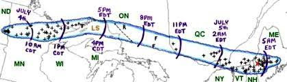
During the pre-dawn hours of that July 4th, thunderstorms were cropping up out in the Dakotas, and they eventually organized into a bow echo on Doppler radar indicating a building derecho – a widespread and long-lived straight-line wind storm or quasi-linear convective system accompanied by violent down bursts. Damaging winds were occurring by the time the storm began moving across Minnesota to become known as the "Boundary Waters - Canadian Derecho." It would last over 22 hours, travel more than 1300 miles at an average speed of almost 60 mph, resulting in widespread devastation and numerous casualties in both Canada and the United States. Little did I know that evening that before morning it would have crossed Ontario and moved into western Québec north of Montréal with up to 6000 lightning strikes per hour and widespread wind damage. It arrived in the Montréal metropolitan area at 2 to 3 am causing serious damage before reeking havoc on the Eastern Townships of Québec and neighboring area of northern New England with winds upward of 90 mph. A tree farm in Sawyerville, Québec just a few miles northwest of where I was sleeping had most of its 2000-3000 trees destroyed.

The full impact of the storm became evident once the sun began to rise. The power was out to a wide swath of southern Québec and northern Vermont and New Hampshire, and after a cold breakfast at the lodge I took a drive to have a look around. Hundreds, if not thousands, of trees were down and branches were scattered everywhere. Wind gusts to 90 mph were measured near Colebrook and around the North Country. I crossed the border into Canada where Hydro-Québec reported that from the Montréal area into the Eastern Townships 600,000 customers had lost electrical power. Power would remain out for over a week in some places. I eventually crossed back into the USA at Coburg Gore, Maine which also experienced the destructive derecho winds. I found more trees splayed on the ground the result of vertical wind shear and micro-downbursts embedded in a broader swath of strong but less severe winds produced by the parent convective system. The derecho continued to cause damage across central and southern Maine before dissipating when it reached the Atlantic coast. The very long-lived “Boundary Waters-Canadian Derecho” was one of farthest northern derechos to have been recorded having destroyed hundreds of square miles of trees. Two people were killed and 70 were injured, almost all of them the result of falling trees or tree limbs. Despite all the damage, I consider myself lucky to have experience the full impact of such a historic derecho.
.jpg)


The tornado then struck the US Department of Agriculture Research Center, causing an estimated $41 million in damage to buildings and research documents. Before it was over 861 residential homes, 560 vehicles, and at least 23 commercial businesses were destroyed or damaged at an estimate of over $73 million. The September 24, 2001 tornado is noteworthy because of its nearly 17 mile track, and it remains the only long-track event with an intensity of F3 or greater to directly impact on the greater Washington, DC, and adjacent suburban Maryland region since then.
Recently I have been watching videos about tornados and the exploits of storm chasers, that fellowship of adrenalin-fuel meteorology junkies who seek out and track developing thunderstorm systems in “Tornado Alley” of the Great Plains – a reference to the region in the US Midwest that sees the most tornado activity. This is nothing I have ever done on my own save the occasional detour to check out areas recently impacted by severe storms. But I have long been curious what it would be like to be on the front line. I will have more to say about this is a future posting. So stay tuned.
No comments:
Post a Comment